Skip To Main Content
 Screen Reader Access

Dhamtari is abbreviated from “Dhamm” + “Tarai”. Dhamtari is situated in fertile plains of Chhattisgarh region. Dhamtari district is officially formed on 6th July 1998 dividing the Raipur district currently the Capital of Chhattisgarh along with Mahasamund district. Its head-quarter is Dhamtari
It is said that the present name of Dhamtari (Sacred Kund) originated from DharamtaraiphraseologyDhamtari is one of the renowned district of the state and contributing the prominentrole to make the state "Rice Bowl." Dubraj and Madhuri are some famous rice verities whichare spreading their essence of not only the state but in whole India. The district is surroundedby 6 other district namely Raipur, Durg, Balod, Bastar, Kanker and Gariyaband
• Physical Features : It is surrounded by Raipur district on North, Balod (newly formed district) on the West, Whereas, Uttar BastarKanker on the South-West. Some part of Odisha State on the South. Total area of Dhamtari district is 4084 Sq.km. Southern part of Dhamtari district comes under mountain region. These mountains of Sihawa group spread over Nagri tehsil and west of Sondhurghati.
• Drainage : One of the major rivers of North India is Mahanadi, which originates from the Sihawa hill ,located on the east of Nagri tehsil. Mahanadi is the principal river of the Dhamtari district and it is so far named as Kankannadi, Chitrotpala, Neelotpala ,Mandvahini etc. The chief crop of this district is paddy. RavishankarSagar dam that irrigates almost 57000 hectare of land, also acts as a main supply unit of safe drinking water source for state capital Raipur. Asia’s first Siphon dam was build in year 1914 at madamsilli dam.
• Climate: The summer season of the district is hot and dry and the monsoon season brings enough rain. The average rainfall of the district is 1221 mm. The southwest monsoon starts from mid June and lasts till the end of September. The minimum temperature goes down to 5.5 degree C during winter season.
• Forest: Out of total area of 4084 Sq.km. of the district, 213123 hectare is forest land. There are three main forest ranges. Viz. Dhamtari range, Birguri range and Nagri range. apart from Sal and Teak trees, there are other similar varieties of trees are Saj.Koha, Harra,Bija and Kumbi.
• Transport and Communications : The district is situated on National Highway-30 and it is well connected by road with state capital Raipur in the North and Jagdalpur (in Bastar district) towards South. The total lenght of National Highway in the district is 60 Kms
Geography
Dhamtari is in the fertile plains of Chhattisgarh. The district's total area is 4,084 square kilometres (1,577 sq mi), and it is about 317 meters (1,040 feet) above sea level. It is bordered bythe Raipur and Durg districts to the north, the Gariaband district to the east, the Kondagaon district and the State of Orissa to the south and the Balod and Kanker districts to the west. The fertility of the land in the Dhamtari District is due to the Mahanadi River and its tributaries (Sendur, Pairy, Sondur, Joan, Kharun, and Shivnath).dhamtari is situated 65 km from capital Raipur
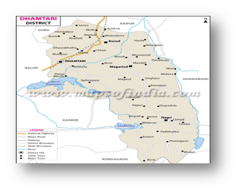 Map of District - Dhamtari (C.G.)
| S.No. | Source | Area (in Lakh Ha.) | % of Total Irrigated Area |
|---|---|---|---|
| 1. | Canals | 59,298 | 39 |
| 2. | Tanks | 465 | 0 |
| 3. | Tube wells | 83,050 | 55 |
| 4. | Wells | 4,040 | 3 |
| 5. | Others (Rivers, Pokhars) | 4,100 | 3 |
| Total | 1,50,953 | 100 |
| S.No. | Subject | Details | |
|---|---|---|---|
| 1. | Total geographical area | 408.19 m ha. | |
| 2. | Total paddy cultivated area | 1.28 m ha. | |
| 3. | Total leguminous crop area | 3.73 m ha. | |
| 4. | Total oilseed crop area | 0.8 m ha. | |
| 5. | Others (Rivers, Pokhars) | 1,560 ha. | |
| 6. | Total vegetable crop area | 79.19% | |
| 7. | Irrigation by resources | 106.45 ha. | |
| 8. | Traditional crop area | 1.34 m. ha. | |
| 9. | Total forest area | 2,12,550 ha. | |
| 10. | Agriculture area | 1,40,050 ha. | |
| 11. | Grass land area | 15,570 ha. | |
| 12. | Irrigated area | 1,31,423 ha. | |
| 13. | Soil Types- (a) Matasi (b) Dorsa (c) Kanhar (d) Bhata (e) Kachhari |
27,749 ha. 23,960 ha. 74,415 ha. 7310 ha. 4,098 ha. |
|
| 14. | Rain Fall | 1221 mm. | |
| 15. | Main Crop | Paddy & Vegetable | |
| 16. | Population (a) Male (b) Female |
7,99,119 3,97,250 4,01,575 |
|
| 17. | Literacy Rate | 78.95% | |
| 18. | Sex Ratio | 1000:1012 | |
| 19. | Tehsils | 05 | |
| 20. | Blocks | 04 | |
| 21. | Total Village | 643 | |
| 22. | Pin Code | 4,93,663 | |
| 23. | STD Code | 07722 | |
| 24. | Vehicle Code | C.G. 05 |


Copyright © 2024 - All Rights Reserved - Official website of CARS, Kurud, Chhattisgarh, India
Note: Content on this website is published and managed by CARS, Kurud, Chhattisgarh
Site Designed and Developed by TECH SOLUTIONS Mob.9977223209
For any query regarding this website, please contact the web information manager: Dean, CARS, Kurud
E-mail ID: cars.kurud@igkv.ac.in